Range Projection function
The distance to a target located anywhere in the water column can be measured in two ways. This can either be the horizontal distance to the target (True), or along the tilt angle (Slant). The Range Projection function defines how this distance is measured.

How to open
This function is opened from the Active menu.
Description
Use the Range Projection function to control how the distance to a target is measured in a horizontal view. This is a "selector" function.
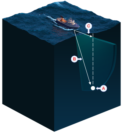
- Target
- Select Slant range to measure the distance to the target diagonally along the tilt angle.
- Select True range to measure the distance horizontally. This is the distance you must sail to position yourself on top of the target.
Note:
The map is only shown in Horizontal views when Range Projection is set to True.